Showing posts with label Geography of population growth. Show all posts

Saturday, April 7, 2018

2870. Tehran in Numbers: Crowded, Low-Cost and Fashion Conscious

By Mona Chalabi, The Guardian, June 30, 2014
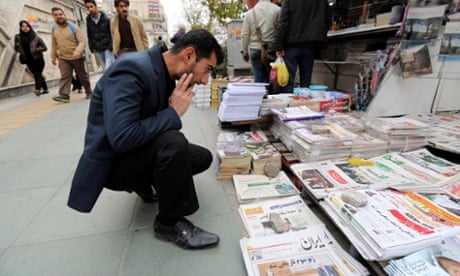
Photo: Abedin Taherkenareh
To the outside world, Iran has been overtaken by images of its leaders on podiums. As a city, Tehran has become synonymous with the political language of those men. If you want to get past the hyperbole, data speaks volumes.

Five rail lines

In 1999, line 5, the first of the Tehran metro system was opened to the public. Since then, it's been joined by four others (lines 1, 2, 3 and 4) and the carriages that travel along its air conditioned tunnels are considered the cleanest in the world.


Tehran Metro
Pinterest
 Image: Tehran Urban and Suburban Railway Operation Co

The metro carries nearly 2 million passengers each day, representing about 12% of the trips made in the city. That might seem low given the convenience of such a well-planned network that's attracted investment interest from China.


Rail transport prices may seem low (you can compare them above) but for a city that has a large number of unskilled workers and where one in five live below the poverty line, it's still an expensive mode of transport. Especially so when bus trips can cost as little as 1p. The accessibility of buses has also had other consequences – the city's large number of female bus drivers.


Female bus drivers in Tehran
 Female bus drivers in Tehran. Photograph: /Image: Tehran Urban Bus Company

1.6 people per room

To get a better reading of the city's heartbeat though, you need to listen to the 13 doctors who checked it on behalf of the World Health Organisation. They went into five (of the city's 22) districts to collect data on 42 different indicators – one of which was the number of people per room in a household.
On average, excluding kitchens, bathrooms and storage rooms, there were 1.6 people per room in each of the city's homes. That might not be surprising given that the city has about 12 million inhabitants packed into 1,500 km squared. Swelling at a rate of 1.3% each year, the south and east of the city remain the most dense, while newer parts still have a lower population density.


Population density
 Population density. Photograph: Iranian census 2006

75% of Tehranis have a freezer, 55% have a personal computer

In some parts of the city, almost one in two households don't have a freezer while in others (presumably the more prosperous areas) that figure drops to one in 10. There are similarly big gaps in personal computer ownership which averages out at 55% of households. Outside of the capital, those figures plummet. According to the statistical centre of Tehran, 33.4% of households have a computer.

Fashion capital

For some women, the Islamic dress codes in Iran pose no obstacle to expression and innovation in fashion. The Tehran Times, a creation of Araz Fazaeli, has developed a mass following – over 13,000 on Instagram and 18,000 on Facebook. It showcases a more vibrant side of the city.
It isn't the only blog in town either. From the Azad art gallery to the Guardian's very own Tehran Bureau there are a lot of people who have something to say online.


Tehran Times
 Image: The Tehran Times

Cost of living

Prices may have soared under sanctions but the city is still relatively cheap. In 2011, the Economist Intelligence Unit ranked Tehran the fourth cheapest city out of 134 that they looked at. According to Expatistan, a collaborative database that crowdsources prices, the typical monthly rent for a furnished, fancy 85 metres squared piece of accommodation will cost around 41.3m Iranian rial (£1,000).
Below are some other prices that indicate how much a typical year in the city might cost.


An anxious city

6.5% of people in the city suffer from somatisation (anxiety) which would be the explanation some residents may give for the city's bad habits. On average 16% of men (and 1% of women) smoke and residents eat an average of 2,400 calories – 36% of people are overweight in the city.


Iranians in Tehran coffee shop
 A Tehrani coffee shop. Photograph: Morteza Nikoubazl/Corbis

Living four years longer

Despite that, residents of the capital have a life expectancy of 77 years, ahead of the Iranian average of 73. Think there must be something in the water? There is: 2.5% of households had "undesirable results" when microbiological tests were conducted on their tap water.
What data would you like to find out about Tehran? Which city would you like to see in numbers? Share your statistics and your suggestions below.
And if you enjoy finding numbers so much that you do it for a living, why not contribute to this Cities in Numbers series? Write to us at cities@theguardian.com outlining your experience and ideas.

Monday, July 14, 2014

1481. For Biggest Cities of 2030, Look Toward the Tropics

By Floyd Norris, The New York Times, July 11, 2014

REALLY big cities used to be primarily in rich countries. But as the world has urbanized, that has changed.
The United Nations this week released its estimates of population in the largest cities — or “urban agglomerations” as the organization calls them because the areas do not necessarily conform to city boundaries — and found that just eight of the 30 largest cities were in countries that the World Bank defines as high income.
That compares with 20 of the top 30 in 1950, the first year for which the United Nations has data. By 2030, the organization projected, only four of the 30 largest cities will be in nations now viewed as high income. Those are Tokyo and Osaka in Japan and New York and Los Angeles in the United States. Of those, only one, Tokyo, will be in the Top 10. That area, which now has 37.8 million people, is expected to remain the world’s largest, but to decline to 37.2 million by then.
“Many countries are urbanizing at lower levels of development” than in the past, said John R. Wilmoth, the director of the population division of the United Nations. As people leave the countryside because of decreasing need for agricultural workers, he said, the important question will be whether cities have an industrial economy that can provide jobs and an infrastructure that can allow the new residents to live in acceptable conditions.
He said that it was easier and less expensive to provide such services as housing, health care, education, electricity and clean water to urban residents than to a similar number of people living in rural areas. But, noting the slums surrounding some cities in poor countries, he added that it was much more difficult to accomplish that after those slums grow.
“It is much better if the planning takes place before they arrive,” he said. “Hopefully, this report is something of a wake-up call.”
New York, which in 1950 was the largest urban area in the world, with 12.3 million residents, now has 18.6 million but ranks only ninth. In 1950, New York and Tokyo, with 11.3 million people, were the only areas with more than 10 million people. Now, there are 28 such areas, many of them in developing countries.
Two of them — Dhaka in Bangladesh and Kinshasa in the Democratic Republic of Congo — are in countries that the World Bank considers to be low income, meaning that the country’s gross national product is less than $1,046 per person. Eight more are in countries with per capita figures under $4,126, making them lower-middle income according to the World Bank. Those eight include three from India and one each from Egypt, Indonesia, Nigeria, Pakistan and the Philippines.
As recently as 1980, areas with more than a million people accounted for 13 percent of the world’s population. Now, the figure is 22 percent, and the United Nations forecasts that will rise to 27 percent by 2030.
The increasing urbanization has meant that a greater proportion of those living in large urban agglomerations are in the tropics, including 11 of the 30 largest areas in the world. Of the 1.5 billion people who now live in areas with at least one million people, 35 percent are in the tropics — defined as being between the tropics of Cancer and Capricorn. In 1970, when only 406 million people were concentrated in areas with more than a million people, just one-fifth of them were in the tropics.

That calculation does not count São Paulo, Brazil, the fifth largest urban area in the world, as being in the tropics, because its center is just south of the Tropic of Capricorn. But much of the population of the region lies north of the line, and the Brazilian government classifies the region as tropical. If São Paulo were counted as tropical, the tropical share this year would rise to 36 percent.